


-
TL;DR: SOCOM is testing a mobile platform that lets operators pull commercial satellite imagery and analytics directly onto Android ATAK devices, reducing reliance on centralized intelligence workflows. Built by SkyFi, the system aggregates data from over 150 providers and aims to deliver mission-relevant imagery at the tactical edge, even with limited connectivity by prioritizing localized datasets and preloaded content. The effort reflects a broader shift toward real-time, on-device intelligence access for dispersed forces, with potential uses extending to law enforcement and emergency response.
Contract and purpose
U.S. Special Operations Command is evaluating a mobile software platform designed to give operators in the field direct access to commercial satellite imagery and imagery analytics on handheld Android tactical devices. The effort is being led by Austin-based geospatial data firm SkyFi under a Phase I prototyping contract of undisclosed value.
According to the company, the award was made through the Special Operations Forces Acquisition, Technology, and Logistics Center. SkyFi said the work includes development of a prototype platform, called the Sovereign Intelligence Platform, along with an Android Tactical Assault Kit, or ATAK, plugin and exploratory field testing with SOCOM personnel.
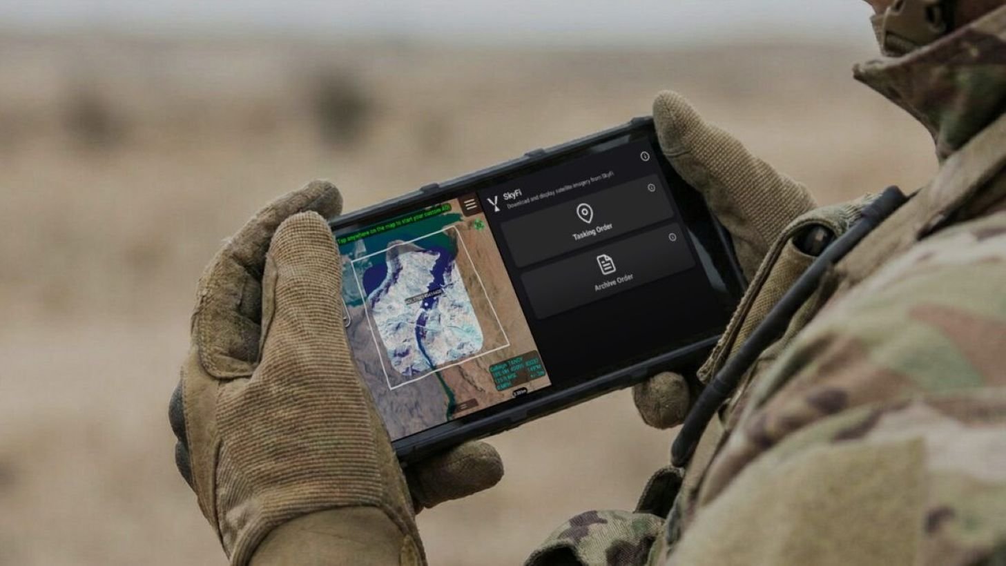
Integration with ATAK devices
ATAK is widely used by military and law enforcement units on ruggedized smartphones and tablets for battlefield awareness, mapping, and mission coordination. The platform supports a growing ecosystem of plugins and data services that combine maps, friendly force tracking, drone video, sensor inputs, and other operational information in a single interface.
SkyFi’s objective is to add commercial Earth-observation data to that environment. The company aggregates imagery and analytics from a large network of commercial providers rather than operating satellites itself. It says its marketplace includes optical imagery, synthetic aperture radar, hyperspectral data, and related analytics from more than 150 satellite providers.
Shift toward tactical-edge access
The project reflects a broader shift in how military users consume intelligence as commercial satellite constellations expand and cloud-based delivery improves. Instead of relying only on imagery routed through centralized analysis centers, operators increasingly want direct access on mobile devices during missions, particularly in dispersed or communications-constrained environments often described as the tactical edge.
Under current processes, personnel typically submit imagery requests before operations through centralized channels, with limited ability to retrieve archived imagery or request new collections once deployed. SkyFi’s software is intended to let users preload relevant local data before a mission, pull archived imagery in the field, and request new collections when connectivity is available.
Technical limits and bandwidth constraints
Some functions still depend on cloud access, including direct satellite tasking. Bandwidth is a central constraint, particularly in denied or degraded communications environments. Rather than pushing large imagery volumes to deployed forces, the concept emphasizes delivering smaller, localized datasets tied to the user’s operational area.
SkyFi chief executive Luke Fischer, a former U.S. special operations aviator, said the company built the software for military users seeking faster access to imagery and AI-enabled analytics on mobile devices. He also said the company has tested similar direct-to-device imagery systems with military units outside the United States for more than a year.
Broader market and potential users
Although the current work is focused on SOCOM, the model has potential applications beyond defense. SkyFi said it is also marketing related capabilities to civilian agencies and emergency-response organizations that already use ATAK, including law enforcement, firefighting, and forestry services.
Fischer said ATAK has more than 500,000 users across military, public safety, and government communities. SkyFi added that engineers with prior experience at Uber helped develop the application, with the design centered on moving geospatial information more directly to frontline users.
Recommended Comments